Africa, drawn into twelve lines
Narrowed from 55 candidates by the Commission's CUSA mapping, the shortlist runs to eleven strategic corridors — twelve including the Lobito Corridor, singled out as the flagship priority. Each is a route from the interior to a coast.
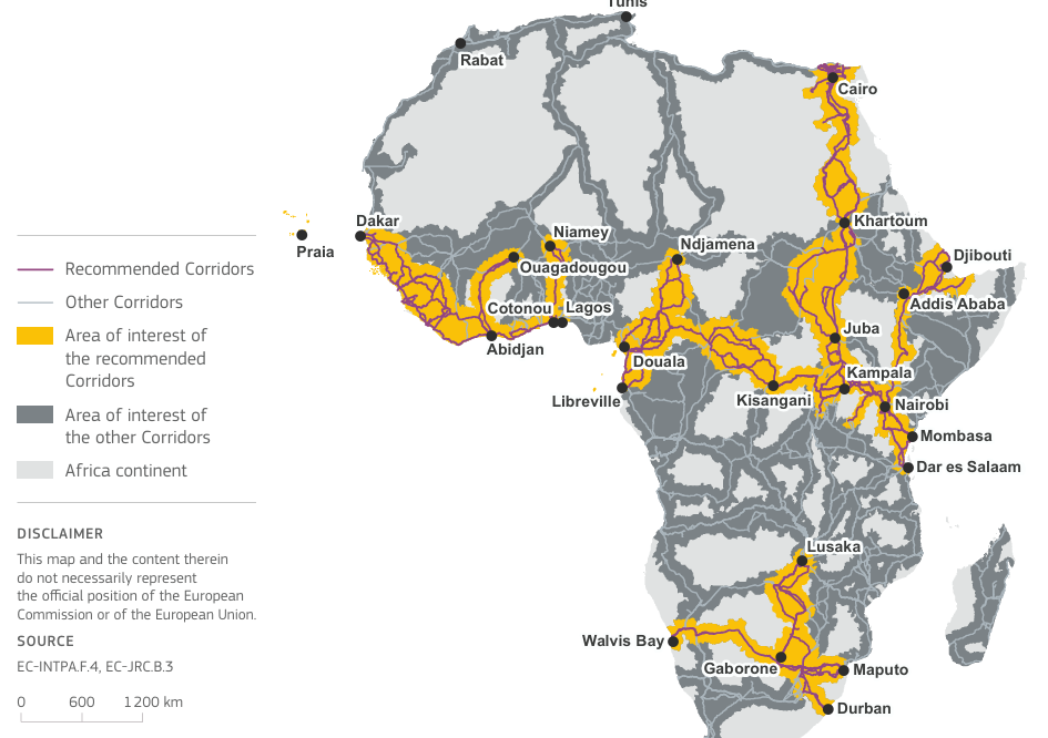
Abidjan–Lagos
Western AfricaDakar–Bamako
Western AfricaPraia–Dakar–Abidjan
Western AfricaDjibouti–Addis Ababa
Horn of AfricaLAPSSET
Eastern AfricaNorthern Corridor
Eastern AfricaCentral Corridor
Eastern AfricaCairo–Cape Town
ContinentalMaputo Corridor
Southern AfricaNorth–South Corridor
Southern AfricaLobito Corridor
Southern AfricaThe measures that decided which corridors mattered
A shortlist built from 140 quantitative indicators. Six of them reveal what the exercise was really weighing.
How much the region trades with the EU — absolute and relative EU exports and imports.
Estimated availability of mineral resources, expressed as the number of mining locations.
The share of the corridor projected to be used for agriculture by the year 2050.
World Bank versus Chinese financing of projects in the corridor between 2004 and 2014.
Connections between container ports in the corridor and container ports inside the EU.
The number of violent events, demonstrations and non-violent actions from 2015 to January 2021.